Data-defined properties in QGIS 2.0
In QGIS 2.0, the old “size scale” field has been replaced by data-defined properties which enable us to control many more properties than jut size and rotation. One of the often requested features – for example – is the possibility for data-defined colors:

Today’s example map visualizes a dataset of known meteorite landings published on http://visualizing.org/datasets/meteorite-landings. I didn’t clean the data, so there is quite a bunch of meteorites at 0/0.
To create the map, I used QGIS 2.0 feature blending mode “multiply” as well as data-defined size based on meteorite mass:
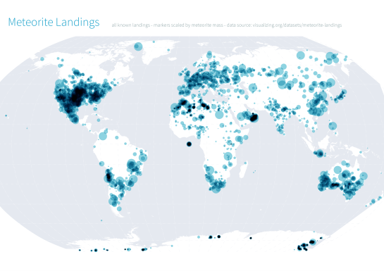
Background oceans and graticule by NaturalEarthData.

Pretty neat, thanks!
Where can I download qgis 2.0 for testing? It really looks promising! Thanks
Depending on your operating system, you can find the current development version (which will be released as 2.0 soon) from http://download.qgis.org.
Reblogged this on AJG-Develop.
Lovely!
Do you have a good example with the color attribute? I’m trying to use it for line and cannot get it to work.
I am trying to follow your example with some earthqauke data but I am struggling to find the right expression for the data defined size of each element. Can you recommend me some source where I can learn more about it?
I copied your expression without knowing anything about it and tried to insert some random numbers and my size-defining field. Up to now, it only changes the size of every symbol to one same size without any connection to my size-defining field.
The expression above maps values between 0 and 1,000,000 to sizes between 0 and 2,000. If the random numbers you put into the size-defining field are rather small, that would result in almost no discernible symbol size difference. If you keep having problems, please post details and screenshots on http://gis.stackexchange.com for support.
Ah, thank you very much! There was no difference to realize beacuse the difference of the numbers in the data defining field were very small compared to the mean of these numbers.
Go on with your blog! i love it and it helps me very much to motivate for GIS self training.