Archive

Tag Archives: FOSS4G

It’s been a couple of busy weeks, with the QGIS 4.2 release and meetings and conferences all over the place before a few, hopefully quieter, weeks of summer break.

QGIS

The Austrian QGIS user group met online on 25 June to exchange experiences with different webmapping solutions, ranging from QGIS+Lizmap to QGIS Cloud.

A few days later, QGIS 4.2 was released on 3 July 2026. This release is named Belém do Pará, after the Brazilian city that hosted both FOSS4G and a QGIS user meeting back in 2024. MundoGEO has the details on the naming, if you’re curious about the backstory. Worth noting: 4.2 “Belém do Pará” will be the next LTR, so if you’re using the long-term release, this is the one to watch for.

What I found interesting while designing the Belém splash screen was that historic maps of Belém don’t have north at the top. Instead, they’re rotated with north pointing either left or right. A nice little reminder that “north-up” is just a convention and not a law of cartography.
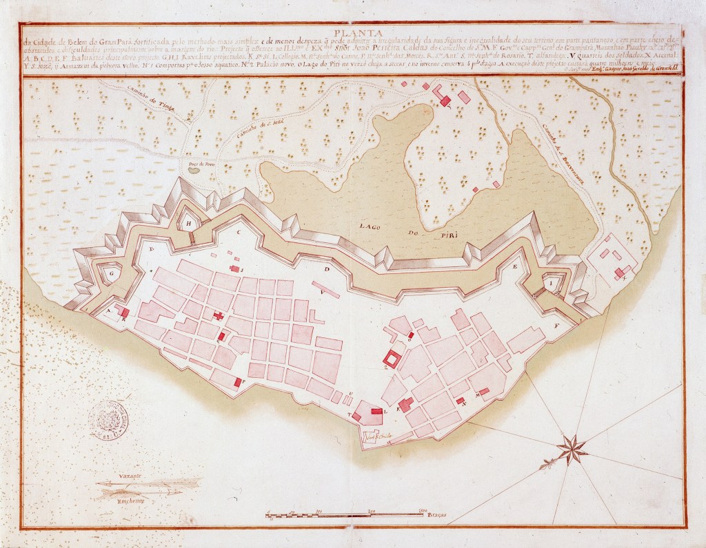
Historic map of Belém used in the QGIS 4.2 splash screen. Source: https://commons.wikimedia.org/w/index.php?title=File:Planta_da_Cidade_de_Belem_do_Gram_Par%C3%A1_(ca._1773).jpg

AGIT 2026

This week, I made my way to Salzburg for AGIT, my favorite Austrian GIS conference.

On the first day, I took part in the AGEO Podium discussion, together with Andreas Hocevar (the father of OpenLayers), Clemens Portele, and Soyol Marksteiner on the OGC API standards, since many users aren’t even aware of these new standards yet.

MobiML architecture overview. Photo by Michael Szell. Source: https://datasci.social/@mszll/116889779516757509

Thursday was talk day for me: I presented MobiML, a new Python library designed to streamline the development of machine learning workflows for trajectory data. I hope this library can help make Mobility Data Science more approachable and results more reproducible.

Right after my talk, Michael Szell presented “Assessing the Danish Bicycle Node Network”, building the data and algorithm foundation for active mobility planning and research. If you want to dig into the tools behind it, check out bikenetwork.dk and bikenetkit.org.

Michael is giving a full talk on this on Tuesday at the Complexity Science Hub in Vienna, if you want to hear more.

FOSS4G Europe, from the sidelines

Unfortunately, I missed FOSS4G Europe in Timișoara the week before, so I followed along via the #foss4ge2026 hashtag instead. Iván Sánchez’s talk on the BOSCO ruling, arguing that all government software must be explainable, is just one example of the talks I would have loved to see in person. There was also the already traditional QGIS Feature Frenzy by Kurt Menke and a QGIS hydrological analysis workshop by Hans who also has a full FOSS4G Europe 2026 summary worth reading.

Also relevant: the Birds of a Feather session on AI in OSGeo projects has spilled over onto the OSGeo discuss mailing list. Definitely a thread worth following or getting involved in if you maintain or contribute to open source geospatial projects.

What’s next

Besides MobiML, work also continues on the MovingPandas front. There are a few open pull requests I want to work through ahead of the next release.

After the summer break, the conference season picks back up quickly: FOSS4G 2026 in Hiroshima (30 August–5 September), Spatial Data Science across Languages (SDSL) 2026 in Jena (16–17/18 September), and the QGIS conference 2026 in Switzerland (5–6 October), where I’ll be speaking about AI in the QGIS ecosystem.

For a more complete picture of what is going on in geospatial worldwide, check out (and don’t forget to bookmark) Jakub‘s comprehensive list of geospatial conferences at github.com/Nowosad/geospatial-conferences.

Over the last two weeks, I had the pleasure to attend both the international FOSS4G conference in Bonn, Germany, as well as the regional FOSS4G-NOR in Oslo, Norway. Both events were superbly organized and provided tons of possibilities to share experiences and find new inspiration.

Talks at both conferences have been recorded and can be watched online: Bonn / Oslo

I enjoyed having the opportunity to give two very different talks. In Bonn, I presented work on pedestrian routing and navigation, which was developed within the PERRON project:

It was particularly nice that we had plenty of time for Q&A after this presentation since only two talks were scheduled for this session rather than the usual three. I’d also like to thank everyone for the great feedback – both in person and on Twitter!

In Oslo, I had the honor to give the opening keynote on OpenSource in general and the QGIS project in particular:

2 – Anita Graser – QGIS – A Community-powered GIS Project from krokskogstrollet on Vimeo.

Both conferences were packed with great sessions and talks. If I had to pick favorites from last week’s presentations, I would have to opt for Iván Sánchez presenting his latest projects, including what3fucks and geohaiku:

6 – Iván Sánchez Ortega, Mazemap – Addressing NSFW Geodesic Grids from krokskogstrollet on Vimeo.

Followed closely by the impressive project presentations of the student organizers of FOSS4G-NOR:

10 – Program Committee – What are the results when students use Open Source? from krokskogstrollet on Vimeo.

All three projects: OPPTUR, GISTYLE, and the flexible traffic web viewer were great demos of what can be achieved with open source tools. Mathilde’s GISTYLE project is also available on Github.

An inspiring GISummer comes to an end, but with so many videos to watch and workshop materials to explore, I’m convinced that the autumn will be no less exciting.

If you want to become an active part of this year’s FOSS4G, it’s now time to start thinking about your contributions!

FOSS4G 2014 will be taking place in Portland, Oregon, USA from Sept 8th-12th. Like last year in Nottingham, there will be a regular track for presentations as well as an academic track and a series of workshops.

logo_horiz_500x231

If you are looking for inspiration, you might want the check out last year’s programme or read about the interesting story behind this years conference logo.

Great shot! – photo by Kenneth Field

FOSS4G 2013 in Nottingham is history. It was my first FOSS4G and a great event. Meeting so many people for the first time in person is really exciting. I had the great chance to present some of the work I did at AIT on comparing street networks. If you couldn’t make it to the conference or missed my talk, here’s the chance to hear it again:


(Tip: You’ll find many more FOSS4G presentations on Youtube.)

Slides and the paper are listed on my publications page. If you are interested in the code, you can find it on Github.

So far, I couldn’t find Tim Sutton’s QGIS keynote video on Youtube. Maybe it will be uploaded later. In the meantime, you can enjoy his slides.

Of course, you already know that the release of QGIS 2.0 was also announced at FOSS4G. In case you haven’t seen the great list of new features yet, have a look at the visual changelog.

Map Gallery – photo by Kenneth Field

The results of the FOSS4G 2013 map contest have also been published now. Thanks to everyone who voted for my entry “FLEET Taxi Tracking” which made it to Runner-up: Best Anti-map Map!

It’s almost here, the biggest open source GIS event of the year: the FOSS4G 2013 in Nottingham. It’s going to be my first visit to FOSS4G and I’m looking forward to present a project I did together with two colleagues at AIT where we compared OpenStreetMap to the official Austrian street network using tools developed in QGIS 1.8 Sextante. The presentation is scheduled for the first day and it would be great to meet you there:

I also have the honor to present Victor Olaya’s Sextante/Processing in a workshop together with Paolo Cavallini on the 20th:

I guess I owe Victor a geobeer or two ;-)

See you in Nottingham! And for those who can’t make it to the UK: I’ll try to keep you posted if the conference wifi allows it.

Now that FOSS4G 2010 is over, we’re looking forward to next year. The free and open source GIS community is going to meet in Denver from September 12-16, 2011.

For all of us who couldn’t attend FOSS4G in Barcelona this year there are some of the great workshops available online:

FOSS4G 2010 conference in Barcelona is coming closer and closer. Have a look at this year’s presentations. Presentations are held on a variety of topics including:

Web Mapping

  • Web Mapping Performance Shootout
  • Web Map Printing with GeoExt
  • Printing in web mapping application: MapFish print module
  • GeoExt and MapFish Client components – how to migrate
  • Where’s MapFish going?
  • A typification of Open Source web mapping client software and frameworks
  • GeoServer CSS – Mapping in Style
  • GeoServer cartographic rendering: new features for map makers
  • Graphical style editing with Styler: Make a basemap without seeing SLD
  • WMS Inspector: a Firefox add-on with tools for working with Web Map Services
  • Performance and statistical analysis of WMS servers
  • Adding custom search engines to OpenLayers with OpenSearch ‘geo’
  • What You Type Is What You See: Comparing two web-based open source approaches to display the results of spatial SQL queries
  • OldMapsOnline.org: Open Source & Online Tools for Old Maps
  • OpenStreetMap-in-a-Box – A Ready-Made Highly Configurable Map Server
  • MapProxy -An accelerating proxy for web map services
  • TileSeeder; a new tile management tool
  • TileCache, GeowebCache and MapProxy – a technical and usability comparison
  • Developing Desktop-like Web GIS Applications with HTML and JavaScript
  • Squeeze: Configuring MapServer and KML to Get The Most Out Of Google Earth
  • PostLBS – Universal WebAPI Platform for Visualizing Geospatial Analysis–Routing, Geocoding, Thematic Mapping and More!
  • Implementing Open Source Tile Caching in a Large Scale US Army Project
  • OpenLayers’ Future
  • Performance Considerations In OpenLayers Based Web Mapping
  • Putting things together: Geonetwork opensource, OpenLayers, GeoExt and MapFish under the roof of Drupal CMS – Geoportal RO as an example
  • MapServer Project Status
  • Hidden features and useful tips for MapServer powerusers
  • Raster data support in GeoServer and GeoTools: recent achievements, unsolved issues and future developments

WPS

  • GeoServer WPS: an integrated, extensible processing service
  • 52º North WPS framework with ArcGIS geoprocessing support – Open Source solution meets closed source software
  • ZOO Project: The powerful WPS Platform
  • Compliance Testing of Open Source software for Web Processing Services
  • Introducing deegree 3 WPS
  • EnviModel: scientific workflows and WPS geoprocessing for climate change
  • Hybrid Cloud Computing for FOSS4G

Training & Education

  • Using Open Source Software in GIS Training and Education
  • Interactive METEOSAT: Educational platform for meteorological applications entirely developed with FLOSS software
  • Why Schools must use FOSS4G

Sensor Web

  • Building a New Generation of Sensor Web Implementations for Hydrology
  • Performance of the 52º North SOS in a real application environment
  • Comparison of SOS-Servers: 52°North, UMN and deegree
  • SOS vs. WFS – Coupling 52° North’s Sensor Observation Service and Geoserver‘s Web Feature Service
  • The New Time Series Toolbox – Next Generation of Sensor Web and Time Series Processing
  • istSOS: Sensor Observation Service in Python
  • How to Discover Sensors in the Sensor Web?

Misc

  • Mobile Augmented Reality using FOSS
  • Vertical Datums: Introduction and Software Review
  • Building a consistent and transparent legal and policy framework for spatial data
  • ecoRelevé: An open source response to the biodiversity crisis
  • GeoSocial, a tool for geospatial analysis and data mining of social networks
  • Real-time position analysis during soccer matches
  • Comparison of Open Source Virtual Globes
  • deegree project report: past, present, future
  • From the crowd sourcing to the institutional sourcing: a way to cooperate between regional and local administration
  • Gesopatial Desktop Comparison
  • Neo4j Spatial – backing a GIS with a true graph database
  • Bridging the Gap Between Open Source Tools and Proprietary Data Sources
  • Open source Geospatial Business Intelligence in action with GeoMondrian and SOLAPLayers!
  • Protect your GIS
  • Introducing OpenScales
  • OSSIM – advanced open source remote sensing
  • State of the art of FOSS4G for topology and network analysis
  • Bringing the raster processing algorithms of the Orfeo Toolbox Monteverdi in QGIS
  • A geospatial data collection system for organisations
  • GeoREST: Open Web Access to Public Geodata Based on Atom Publishing
  • Distributed Spatial Indexing in the Cloud
  • Integrating SEXTANTE and GRASS
  • GeoCat Bridge – One click data publishing
  • Semantic Web approach for thematic structuring of geographic objects
  • Semantic search in OGC Catalog Services for the Web
  • BeETLe project: a free geospatial ETL tool
  • GeoKettle: A powerful open source spatial ETL tool
  • Geomajas: new kid on the block

OSGeo

  • The State of OSGeo
  • International Collaboration on the OSGeo4W
  • OSGeo:Open Source Projects and Communities
  • The OGC and its participatory processes: OGCnetwork, open WG, regional Fora and the collaboration with OSGeo

Mobile & 3D GIS

Inspire & SDIs

  • OpenLayers: SOS and INSPIRE
  • State of Ingres geospatial 2010
  • INSPIRE Geoportal a platform for INSPiRE services
  • Implementing INSPIRE with FOSS4G: a Success Story
  • GeoNetwork opensource – The geospatial metadata catalogue
  • Implementation of ISO and OGC (INSPIRE) metadata standards – MEDARD (FOSS) metadata editor and Internet Geoinformation Metadata Platform (IPMGeo)
  • Authentication and authorization management to OGC services with GeoShield: improvements from FOSS4G 2009
  • License and Permission-based access to OGC Web Services with 52°North
  • Deploying and securing Spatial Data Infrastructures (SDI) with GISpatcher
  • Metadata Reloaded – How to profit from INSPIRE
  • GeoNode Architecture: Wrangling $100 million worth of open source software to make SDI building a walk in the park

PostGIS & PGRouting

  • Shortest path search for real road networks with pgRouting
  • An extension of PGRouting library functions for visibility-graph-based course calculations in a Vessel Traffic Management System (VTMS)
  • Tips for the PostGIS Power User
  • Running long and complex processes with PostGIS
  • PostGIS meets the third dimension
  • Introducing PostGIS WKT Raster: Seamless raster/vector operations in a spatial database
  • PostGIS WKT Raster. An Open Source alternative to Oracle GeoRaster
  • The State of PostGIS
  • Moving from Oracle/ArcGIS to PostGresql/PostGIS

Other Geodatabases

  • Geospatial Indexing with MongoDB
  • GeoCouch: A spatial index for CouchDB
  • Beyond PostGIS – New developments in Open Source Spatial Databases
  • SpatiaLite, the Shapefile of the future?

GIS Data

Applied GIS & Use Cases

  • A WebGIS application to monitor Road Trafic
  • GeoServer, GeoTools, GeoBatch: relying on the “usual suspects” for supporting operational Meteorology and Oceanography
  • Building the Digital Observatory for Protected Areas on an Open Source Framework
  • Open-source Earthquake and Hydrodynamic Modelling
  • Open Environmental Services Infrastructure
  • Case Study: Upgrading Guatemala’s SDI portal to a GeoNode
  • Proprietary to FOSS: MapServer as a key component in the map distribution infrastructure of the Norwegian SDI
  • Applied SDI in Germany – Complying with INSPIRE
  • Coming Full Circle: Archaeology and Open Source GIS, Past, Present and Future
  • Open Government, Open Data, Open Architecture and Open Source Software GIS Policy for U.S. Army Installation Management: 2010
  • Operational use of the Orfeo Tool Box for the Venus Mission
  • Enhancing the European Forest Fire Information System (EFFIS) with Open Source Software
  • ArchaeoloGIS: OSGIS in Archaeological Research
  • The World Meteorological Oganization Information System
  • Introduction of flood evacuation route search system using QGIS, PostGIS, GRASS and PgRouting