5 meter elevation model of Vienna published
A while ago I wrote about the 5 meter elevation model of the city of Vienna. In the meantime the 5 meter model has been replaced by a 10 meter version.
For future reference, I’ve therefore published the 5 meter version on opendataportal.at.
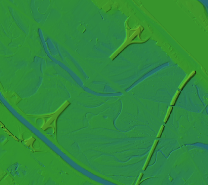
details of the Viennese elevation model
I’ve been using the dataset to compare it to EU-DEM and NASA SRTM for energy estimation:
A. Graser, J. Asamer, M. Dragaschnig: “How to Reduce Range Anxiety? The Impact of Digital Elevation Model Quality on Energy Estimates for Electric Vehicles” (2014).
I hope someone else will find it useful as well because assembling the whole elevation model was quite a challenge.

mosaicking the rasterized WFS responses

Thank you for publishing this 5m elevation raster-dataset!
I tried to mosaik the WFS output together myself, but after 20 downloads, I was thrown back due to a server error… :-/
Hi Anita,
As you’ve used the data from Vienna quite a bit I wonder if you’ve come across data delineating the Danube within the city. Their WFS seems to be temporarily down.
Cheers,
Cyrille
Sure, it should be in the land cover datasets.
I found it under Greenbelt data:
https://open.wien.at/site/datensatz/?id=10c7b88b-a708-4e17-a7ef-2c1ce0590377
(http://data.wien.gv.at/daten/geo?service=WFS&request=GetFeature&version=1.1.0&typeName=ogdwien:GRUENFREIFLOGD,ogdwien:GRUENGEWOGD&srsName=EPSG:4326&outputFormat=shape-zip)
I can’t seem to connect to the WFS from QGIS (http://data.wien.gv.at/daten/wfs?service=WFS&request=GetCapabilities&version=1.1.0) but downloading from the WFS works fine.
I couldn’t find the land cover datasets – looked for Landbedeckung but that probably isn’t the proper term.
C-
QGIS WFS connection to http://data.wien.gv.at/daten/geo and download of FMZKGEWOGD (Gewässer) works for me.
Ah, I was using http://data.wien.gv.at/daten/wfs as per https://anitagraser.com/2011/05/22/wms-wfs-for-vienna-open-data/
Seems obvious now that I look at the WFS data link in the earlier post.
Thanks Anita
Great! I’ve added a note to the post that the information is outdated.